
What is GIS
Geographic Information System (GIS) is a technology designed to capture, store, manage, analyze, and visualize geographically-referenced information. It operates on the principle of using geographic or spatial location as a common key to associate and represent a wide range of data. By managing and processing spatial data, GIS makes it possible to perform complex analysis and quick decision-making.
Geographic Information refers to the data that indicates the location of a specific point or area in space, along with various phenomena related to it. It could be simply location-based data or associated with a variety of events or features. Geospatial information encapsulates a wide range of information including land use diagrams that represent certain themes such as natural phenomena, disasters, socio-economic activities in a region, hazard maps, city planning maps, topographic maps, place name information, ledger information, statistical information, aerial photographs, and satellite images.
GIS in Decision Making
GIS technology is essential in today's digital age as it integrates various types of data, making it easier to understand and visualize. The visual representation provided by GIS can range from simple maps and 3D scenes to more complex web apps and dashboards. With its ability to manage and analyze geospatial data from various sources, GIS can assist decision-makers in addressing challenges related to planning, management, and developmental activities. The applications of GIS are vast, spanning across numerous fields such as urban planning, transportation, environmental conservation, disaster management, and public health, to name a few. By providing a comprehensive view of data, GIS supports informed decision-making, helping societies and organizations to operate more efficiently and effectively.
Types of GIS Data
GIS data comes in various forms, each with unique characteristics that make it suited to certain kinds of analyses.
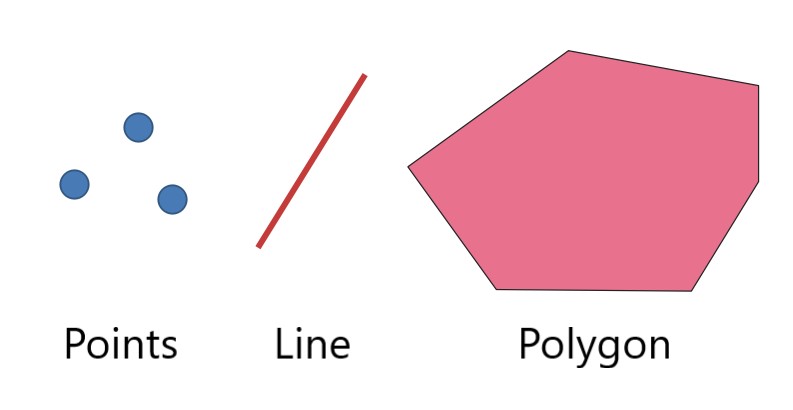
Vector Data
Vector data is a type of spatial data that represents geographic features as points (dots), lines, and polygons (areas). For example, a city can be represented as a point data, and a river can be represented as line data. Vector data is useful for representing discrete features—things that have a clear shape and size.
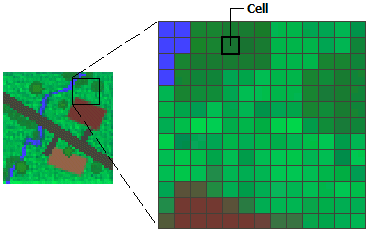
Raster Data
In contrast to vector data, raster data represents geographic features as a grid of cells, also known as pixels. Each pixel holds a value that corresponds to the characteristic of the geographic feature it represents. Raster data is excellent for representing continuous phenomena that do not have clear-cut boundaries or that change smoothly across the landscape—like elevation or temperature.
Attribute Data
Attribute data, also known as tabular data, provides additional information about each geographic feature in a GIS. For instance, attribute data for a city (represented as a point in vector data) might include the city's name, population, GDP, or other relevant statistics. Attribute data is typically organized in table format and linked to spatial data through a common identifier, allowing users to conduct more detailed analyses.
Metadata
Metadata, also referred to as "data about data," provides detailed information about GIS data. It may include descriptions about how the data was collected, the scale or resolution of the data, who collected the data, when it was collected, and any restrictions on its use. Metadata helps users understand the context, quality, and applicability of the data, ensuring that it is used appropriately and correctly.
Combining Multiple Data Types
GIS data can be used alone or combined with other types of data to create more complex and detailed geographic analyses. For example, a user could overlay vector data (representing roads or rivers) on top of a raster data (showing land elevation), and use attribute data to add additional information about the features in the map. This integration of various data types is one of the most powerful features of GIS, allowing for comprehensive analyses and visualizations of geographic information.
Collection and Conversion of Geographic Information to GIS Data
Collecting and converting geographic information into GIS data is a crucial process that requires a number of strategies. Here, I introduce some of the methods commonly used.
Digitizing Maps
One common method of creating GIS data is by digitizing paper maps. This involves scanning the paper map to create a digital image. However, directly extracting GIS data from the scanned image can be challenging. Often, the image is processed through Optical Character Recognition (OCR) software to convert text data, making the extraction more feasible.
Utilizing GPS Technology
The Global Positioning System (GPS) provides a modern and accurate method to collect geographic coordinates (latitude and longitude). It is especially handy for capturing location data on the go. By using GPS technology, accurate location data of places, roads, and other geographical features can be collected in real time, which can then be converted into GIS data.
Manual Input of Geographic Information
While it can be time-consuming, manually inputting geographic information is another way to generate GIS data. This often involves using other sources of information like physical maps, photographs, or observations as references, then manually inputting the geographic features and their attributes into a GIS system.
Acquisition of Public and Private Data
There's a wealth of geographic information available from both public and private entities. Many government agencies and private companies release or sell geographic data related to various fields such as demographics, land use, transportation, and more. Acquiring and incorporating this data into a GIS can provide a rich source of information for analysis and decision-making.
References


Ryusei Kakujo


Weave the future of cities through data
Transportation modeling/ Urban planning/ Machine learning/ Computer science/ GIS